The New River

 The New River’s name is a misnomer, it is actually one of the oldest rivers in the world (although dating a river is difficult).  The New may have been flowing north before parts of the Appalachian Mountains were pushed from the ground during the  Alleghanian orogeny (mountain building event) roughly 320 years ago. As the mountains grew the river scoured and carved the rock away, forcing its way though solid rock.

Looking for Podostemum on the Clinch RIver, VA.

Looking for Podostemum on the New River, WV.

The New River begins on the slopes of northwestern North Carolina then flows into VA and on into WV. There it joins the storied whitewater river known as the Gauley. Here the New and the Gauley form the Kanawha River which later joins the Ohio River near Point Pleasant, WV. Both the New and Gauley offer amazing whitewater boating.

Podostemum found on the New River, WV.

Podostemum found on the New River, West Virginia near the town of Sandstone.

Podostemum on the North Folk of the New River, North Carolina.

Podostemum on the North Folk of the New River, North Carolina.


In Virginia’s ridge and valley province, tributaries to the New River like Walker Creek, near Bland, TN flow between parallel ridges, meandering between lush farmland and remnant forest. Like many other rivers, cows and other livestock have direct access to the river are a contributor to non-point source pollution. When livestock have direct access to the river they muddy the water and erode the stream banks. They also add nutrients (especially nitrogen) and fecal bacteria directly into the water. Fecal bacteria (from human and livestock levels) in rivers is a public health problem worldwide (including the US).

I couldn't find Podostemum in Walker Creek, despite the habitat looking pretty darn good for the plant

I couldn’t find Podostemum in Walker Creek, despite the habitat looking pretty darn good for the plant.

Agriculture is currently exempt from the Clean Water Act of 1977 and a recent court ruling has put on hold regulations from 1977 to protect the many small streams that flow into large rivers, like the New and Gauley Rivers. It’s hard to have clean water in the river without clean water flowing into them.

Cows along the Clinch River.

Cows along the Clinch River, VA. The Clinch is a biologically diverse tributary to the Tennessee River.

Cows in the river on the South Holston River, TN.

Cows the South fork of the Holston River, TN. The Holston is a tributary to the Tennessee River.


After searching for Podostemum in several places in Walker Creek and coming up short, I finally found some growing at the confluence of Walker Creek and the New River. If Podostemum calls the New River home from North Carolina to West Virginia, why wouldn’t it be in this tributary?

OLYMPUS DIGITAL CAMERA

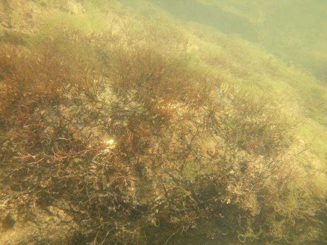
Podostemum ceratophyllum at the confluence of the New River and Walker Branch. This Podostemum doesn’t look very happy to me. It looks quite red which might be a sign of stress in the plant.


Maybe the plant hasn’t had a chance to get there yet, however Podostemum ceratophyllum seems to have been in the Southern Appalachians for a long long time. It was growing near the confluence of the New River and Walker creek, both on the upstream end and on the downstream side; and the plant grows over a large geographic area will little competition from other plants. Perhaps Podostemum isn’t there because of water pollution, but what type of water pollution could cause it to be absent from an entire river?  How do I measure that type of pollution?  Where is the pollution be coming from? Is it from coming from one source or many, and is the pollution always in the water or only sometimes, like when it’s raining? There are more questions than answers…

Please click the “Follow” tab and find out about new posts

The Tennessee River

In mid-August I was driving from a landscape that drains into the mighty Tennessee River into the watershed of the ancient New River. Both of these rivers flow through rich farmland with a bountiful history. More on the New later.

OLYMPUS DIGITAL CAMERA

A country road in western Virginia, in the upper part of the Tennessee River watershed.

The Tennessee River forms as small streams flow westward off the slopes of the Appalachians in NC, GA, AL, TN and VA. The history of the Tennessee River is richly diverse, from the evolution and radiation of numerous aquatic species (over 240 species of fish) to widespread building of hydroelectric dams. The collision of eons of evolution and human actions (dams, pollution, etc.) means we’re at risk of losing unique parts of this national treasure if we don’t have the involvement of the public in protecting them.

Screen Shot 2015-09-19 at 11.07.19 AM

Fontana Lake was made from an impoundment of the Little Tennessee River, in Western North Carolina. Photo from http://www.grahamcounty.net/GCHistory/08-fontana/fontana.htm

The Tennessee River drains the very western corner of VA via the Clinch and Holston Rivers and Western North Carolina via the French Broad, Pigeon, Tuckaseegee, Little Tennessee and Hiawassee Rivers. The later two have their headwaters in Northern Georgia. The Tennessee River Watershed also contains parts of Alabama, Mississippi and Kentucky.

The Tennessee River Drains a large portion of the southeast through Tennessee, then the river take a sharp right and heads north, joining the Ohio River at Paduach Ky. The Ohio River watershed extends from North Carolina to New York State.

The Tennessee River Drains a large portion of the southeast through Tennessee, then the river takes a sharp right and heads north, joining the Ohio River at Paduach Ky. The Ohio River watershed extends from North Carolina to New York State.

The Clinch River flows west into the Tennessee River between long parallel ridges in western Varginia.

The Clinch River is known for it biological diversity and flows west into the Tennessee River between long parallel ridges in western Virginia. In western Virginia the Clinch river is a scenic river to paddle.

The TVA (Tennessee Valley Association) was tasked in 1933 with bringing electricity, flood control, and improved navigation to Tennessee and Western North Carolina, as well as for providing electricity for military projects during WWII. This region was hit hard by the great depression and needed help but now the main stem of the Tennessee River is as much a series of dams as it is a river.

Cliffs along the Clinch River

Rock cliffs overlook the Clinch River in western Virginia

Along the western edge of the Tennessee River watershed in Virginia I looked for Podostemum, exploring sections of several rivers including the Clinch and South fork of the Holston. Unfortunately I couldn’t find Podostemum in these rivers despite the Southern Appalachians being in the heart of Podostemum country. So what gives? What kept me from finding Podostemum here?

[Edited Oct, 27: added “in protecting them”]

The Susquehanna River

The Susquehanna River is a big river that cuts thought forested ridges north of Harrisburg, PA. The river’s eastern branch meanders back and forth between New York state and Pennsylvania  draining large parts of both states. The west branch flows east out of forests in central Pennsylvania joining the rest of the Susquehanna south of I-80 near Sunbury. The Susquehanna joins the Atlantic Ocean at very top of the Chesapeake Bay, once one of the most productive estuaries in the world.

Half falls on the Susquehanna River North of Harrisburg PA

Looking for Podostemum at Half Falls on the Susquehanna River, north of Harrisburg, PA.

Susquehanna River, PA

Susquehanna River is a wide river draining large parts of  Pennsylvania and south central New York state.

Before the hardwood and pine forests Pennsylvania, West Virginia and adjacent states, the land was covered with large swamps. In these ancient swamps grew a strange type of forest, dominated with Lycophyte trees and Fern trees. Dragonflies with 2-3 foot wingspans and surely big enough to eat a baby roamed the sky, truly a different world than today. Today dragonflies and other aquatic insects call these riverbeds home.

These chironomid fly larvae cases covered the river bottom by the thousands. Chironomids can be found in clean and dirty water but to many can be an indicator of poor water quality. These insects can be an important food source for larger predators like dragonflies.

These caddisfly larvae cases covered the river bottom by the thousands on a tributary to the Susquehanna River. These insects can be an important food source for larger predators like fish and dragonflies. Note: I had previous referred to these caddisflies as as chironomids, which are a type of true fly (Order Diptera).

OLYMPUS DIGITAL CAMERA

Caddisfly larvae (order Trichoptera) help filter the water usually live in small cases that they build. Some species use bits of leave or sticks to make their case, other species use sand and small stones, while other species spin nets from silk. Their name Trichoptera mean hair wing, “trich” comes from Greek “thrix” = hair, and “pteron” = wing. This refers to the small hairs on the their wings as adults.

The carbon from these ancient swamp forests makeup the coal and natural gas deposits so actively sought today. Mining for coal and other minerals has been a major economic driver in the region for centuries. Easy access to coal helped a booming industrial revolution. The history is written in the landscape and in carved into the river bed, but also affects the animals living in the water.

Coal Mining in PA. Photo from Mining History PA

Coal Mining in PA. Photo from Mining History PA.

The rivers I visited in the Susquehanna watershed were clear waters with river bottoms of mostly shale and cobbles. Cool water flowed swiftly downstream. Seemingly a great habitat for Podostemum, right in the middle of the plant’s native range (see below) along the Appalachians from Georgia to Canada…so why can’t I find it in these creeks and in the river?

OLYMPUS DIGITAL CAMERA

Pine Creek, near Tiadaghton State Forest

OLYMPUS DIGITAL CAMERA

Pine Creek flows south and joins the Susquehanna River upstream of Willilamsport PA.  Despite the great looking Podostemum habitat, I couldn’t find this plant in this clear water river.

Perhaps Podostemum was never in these river, or perhaps it was but isn’t now…more questions than answers here in these beautiful PA landscape…

Distribution of Podostemum, Philbrick and Novelo 2004. The Podotemum ceratophyllum is the only on that grows in the US and Canada, but most of the diversity of the group is in South America.

Distribution of plant genus Podostemum, Philbrick and Novelo 2004. Podostemum ceratophyllum is the only one of the group that grows in the US and Canada, but most of the diversity of the group is in South America.

Click on the follow tab to be notified when the next post goes up.

Exploring Rivers in New England

New England is beautiful in the summer! Wildflowers abound, fair weather and refreshingly placid landscape. There are several wonderful rivers in New England that I’ve been exploring including the Connecticut and Androscoggin. New England has a rich history and is an outdoor wonderland with montane forests, bogs, lakes and numerous big rivers.

Beautiful New England.

Beautiful New England.

The research vehicle

The trusty research vehicle parked at a boat launch on the Androscoggin River near Gorham NH.

The Connecticut River flows south between the Green Mountains of Vermont and the White Mountains of New Hampshire, then through Massachusetts and Connecticut to the North side of Long Island Sound. The Connecticut is a big river with a rich human and natural history. The Connecticut River valley was farmed early on in American history because of its abundant farmland. With European settlers came numerous dams and the once abundant fisheries of Atlantic Salmon and American Shad among others begin to decline.

OLYMPUS DIGITAL CAMERA

The Holyoke Dam on the Connecticut River, one of many large dams on the River.

OLYMPUS DIGITAL CAMERA

The last dam in a series of dams at Bellows Falls on the Connecticut River.

In Maine and New Hampshire the Androscoggin River runs east along the north side of the White Mountains through central Maine and then turns south, joining the North Atlantic in a rocky cost near Brunswick. The water is dark brown with tannic acids from the peat bogs, but Podostemum is still present, at least in its lower reaches.

OLYMPUS DIGITAL CAMERA

Looking for Podostemum on the Androscoggin River in Northern NH and ME.

OLYMPUS DIGITAL CAMERA

Found it. Podostemum on the Androscoggin river near Lisbon, Maine.

Dams have impacts on migratory fish but how have they impacted Podostemum? If Podostemum provides great habitat for the macroinvertebrates, what happens when Podostemum is lost from the river?

Podostemum chocked full of macroinvertebrates.

Podostemum can be simply chocked full of macroinvertebrates.

Don’t forget to follow click on the follow tab to keep up to date.

Rivers Link Us Together

Rivers connect places together throughout the landscape. Activities that happen upstream (like forest clearing) can have impacts downstream and activities that happen downstream (like building a dam) can have impacts upstream.

“I live downstream” Mr. Crayfish on the Susquehanna River

My research is seeking to understand how changes in land use (like building roads and cities) are impacting rivers by examining a plant that grows throughout the eastern US. The plant, commonly called hornleaf riverweed, aka Podostemum ceratophyllum, grows underwater attached to rocks in swift water habitats. Podostemum supports lots of aquatic insects, but surprisingly little is known about this plant, so I’m exploring how we can use Podostemum to better understand how rivers work and how humans are impacting rivers.

OLYMPUS DIGITAL CAMERA

Riverweed (Podostemum ceratophyllum) can cover vast amounts of the river bottom. It provides food and habitat for aquatic snails, fish, and insects.

Last year I explored rivers in the southeast, learning about where Podostemum grows and trying to understand what influences the plant’s  ability to grow in southeastern rivers.

OLYMPUS DIGITAL CAMERA

Boating and researching on the Chattooga River, GA/SC boarder

The author looking for Podostemum on the Middle Oconee River near Athens, GA

The author looking for Podostemum on the Middle Oconee River near Athens, GA

This year I’m road tripping to the northeast to explore more rivers, collect plant samples and learn more about how rivers work. Some driving questions I’m working on answering include  “Is pollution from urban areas bioaccumulating in this plant?” and “What can this plant tell us about the river’s food chain?”.

Sampling Podostemum on the Connecticut River, MA.

Sampling Podostemum on the Connecticut River, MA.

Collecting some basic water quality metrics, like pH, conductivity and nutrients levels (Nitrogen and Phosphorus)

Collecting some basic water quality metrics, like pH, conductivity and nutrients levels (Nitrogen and Phosphorus)

Because rivers integrate the landscape and Podostemum grows in rivers, I think Podostemum can help us understand how we humans are impacting rivers. By studying Podostemum, maybe we can find ways to reduce our impact on rivers. Keeping rivers clean and healthy is important not only to the great diversity of wildlife that rivers support but also for human health. After all, rivers connect us to each other; and in a very real way, we all live downstream.

Panther Creek GA.

Panther Creek Falls GA is a popular recreation destination. The green swath at the bottom of the falls on river right is Podostemum.

Rivers of History

Rivers are intimately tied to the development and growth of the United States of America. Before paved roads, rivers were the main avenues for commence. Cities sprung up along rivers to take advantage of the ability to move goods up or downstream to new markets. Rivers supplied water for the growth of cities and rivers were dammed for hydropower. Mill dams were common on eastern rivers as early as the 1700’s and were so prolific in the early Eastern Piedmont that their impacts can still be seen today. The industrial revolution and rise of hydroelectric power brought bigger dams, impounding most every eastern drainage of suitable size. Dams have severely impacted the migration of many fish that were once of significant economic value but are now diminished. Fishes that have been severely impacted by dams include American Shad, Sturgeon and Atlantic salmon in the eastern US, pacific salmon species in west. Many non-game fish have also been negatively impacted by dams. In the Northwest and Northeast, dam removal and the restoration of free-flowing rivers is helping to restore these native fish to their historic ranges. Dam removal in the Southern Appalachians and Piedmont has recently moved forward with efforts to restore native mussels, American Shad and other native fishes.

Construction of the Tallulah Dam and Lake, upstream of the Tallulah Gorge.  Image from http://www.rabunhistory.org/photo-gallery/lakes-and-dams/?page=1

Construction of the Tallulah Dam and Lake, upstream of the Tallulah Gorge. Image from http://www.rabunhistory.org/photo-gallery/lakes-and-dams/?page=1

The confluence of the Tallulah (left) and Chattooga (right) Rivers before the construction of the Tugaloo Dam that created Lake Tugaloo. Image from http://www.americanwhitewater.org/content/Photo/detail/photoid/9526/

Before the many dams on the Savannah River and its tributaries, American Shad are reported to have migrated all the way up the up to Tallulah Falls, that’s 383 miles (617 km) from the Atlantic Ocean! But how do we invite these fish back home and restore our rivers?

American Shad (Alosa sapidissima) were once harvested by the hundreds of thousands of pounds in many eastern rivers. Adult shad can be upward of 7 pounds and are known for the delicate savory flavor. image from http://www.chesapeakebay.net/fieldguide/critter/american_shad

American Shad (Alosa sapidissima) were once harvested by the hundreds of thousands of pounds in many eastern rivers. Adult shad can be upward of 7 pounds and are known for their delicate savory flavor. Image from http://www.chesapeakebay.net/fieldguide/critter/american_shad

Don’t forget to click on the link to follow us!

Why are Rivers Important?

Rivers are important, in part, because they provide many important services to people. These services can be called Ecosystem Services and are a way to understand how rivers support human needs and demands. For example, rivers filter water, cleaning it as water flows downstream by supporting organisms that consume waste and pollution from the water. Rivers also support local economics by providing a recreation destination for fishing, boating and swimming.

Georgia River Network Middle Oconee Paddle

Georgia River Network, Middle Oconee Hidden Gems Paddle near Athens Georgia

They also move sediments that replenish beaches, which have recreational and ecological value. Rivers also help recharge groundwater, providing drinking water for people and wildlife, and are a invaluable source of food to people around the world.

OLYMPUS DIGITAL CAMERA

Spotted Bass on the Conasauga River

So what happens when rivers get sick and these ecosystem services stop working? When the river can’t support organisms that clean the water, how do we get clean water? What do we do when the groundwater isn’t replenished and peoples’ wells go dry? How does dirty water impact the economy? What do we do when these ecosystems services are diminished by our own actions?

OLYMPUS DIGITAL CAMERA

Kiosk on the French Broad River at Stackhouse

Rivers support us. But how do we protect this awesome resource?

Why Research Rivers?

Why Study Rivers? A good question with lots of different answers. Really we (humans) don’t know all that much about the ecology of most rivers. We know where rivers flow to and from but connections between groundwater and rivers is quite complicated and poorly understood.  We often know what types of fish live in specific rivers, although we know much less than your might suspect, especially in the Southeast which host a tremendous diversity of native fish. Rivers also work in close connection with the landscapes through which they run.

Etowha River, Georgia

Etowha River, Georgia

Terrestrial insects fall into the river and feed fish, aquatic insects metamorphose, leave the river and are an important source of food for birds and spiders, but we are just learning about the nature of these relationships. Nutrients like nitrogen and phosphorus move from the land to the water, then into organism and back into the water column. Rivers are also important locations for recreation and support neighboring economies. Rivers provide drinking water for cities and towns and rivers provide other important ecosystem services.

French Broad River TN, near NC boarder

French Broad River TN, near NC boarder

So why study rivers? Because they are an important piece of this of this space rock we all live on. They are interesting and vital to a healthy ecosystem and vibrant society. Rivers are exquisitely dynamic and complicated, a beautiful showcase of nature’s power. So… I study rivers because I am simply amazed by them and we (humanity) need them.